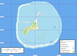
Oenoīeg
Oenoīeg is curalen īeg in þǣm sūðernum Sericus Gārsecge and is dǣl þāra Pitcearnīegena sē is Bryttisc ofersǣ landscipe. Hiere nama nis Polynesisc ac Crēcisc. Þēos īeg hæfþ hiere naman æfter Œno þæt hƿælhuntoþscipe ac Pitcearnƿare secgaþ þone namna mif þrim stæfgefēgum, sƿa sƿa ƿolde man hine secgan gif hē ƿær Polynesisc nama.


Landscipe
adihtOenoīeg līð 89 mīla be norþƿestan Pitcairnīege, æt 23°55′26″S 130°44′03″W / 23.92389°S 130.73417°W. Sēo īeg is ymbe 3 mīla brād. Luh is onmiddan. Hiere stōƿ is 7.7 mīla2 ac hiere land 170 æcre. Oeno is āgebūred ac menn fram Pitcearnīeg seglað hider for tƿǣm ƿucum in Æfterra Geola.[1]
Fruman
adiht- ↑ (2006) South Pacific & Micronesia. Lonely Planet. ISBN 1-74104-304-2. “Unless you've got your own yacht, your only chance of getting to Oeno is in January, when Pitcairners fit out two of their longboats with essential supplies and swap everyday life on Pitcairn for a fortnight's summer holiday on Oeno.”
Ūtƿearde hlencas
adiht- Oeno Photo Tour Archived 2008-12-08 at the Wayback Machine - Pitcairners spending holidays on the island
- Island Evolution: Oeno Island Archived 2006-10-01 at the Wayback Machine from NASA Earth Observatory
- Map of Oeno Island Archived 2007-09-26 at the Wayback Machine