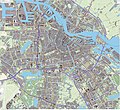
Ymele:Amsterdam-topografie.jpg

Micelness þisre forebysene: 607 be 600 dotta. Oðra metinga brædo: 243 be 240 dotta | 486 be 480 dotta | 777 be 768 dotta | 1,037 be 1,024 dotta | 2,073 be 2,048 dotta | 3,812 be 3,766 dotta.
Frumlicu ymele (3,812 × 3,766 pixela, ymelan micelness: 11.18 MB, MIME cynn: image/jpeg)
Ymelan stær
Swing dæg/tide mid mys to seonne þa ymelan swa heo wæs on þære tide geywed.
| Dæg/Tid | Metungincel | Micelnesse gemetu | Brucend | Ymbspræc | |
|---|---|---|---|---|---|
| nu | 15:03, 11 Se Æfterra Gēola 2013 |  | 3,812 × 3,766 (11.18 MB) | Janwillemvanaalst | Added various topographic improvements, which were already available in the BRT open-geodata source files: - Symbols for special physical appearances of land types such as "swampy terrain" - Symbol for carpool parking + large open parking spaces (in ad... |
| 15:39, 4 Se Æfterra Gēola 2013 |  | 3,814 × 3,766 (10.78 MB) | Janwillemvanaalst | Various rendering improvements, following the advice of several topographic experts. Scale unchanged. | |
| 20:23, 29 Gēolmōnaþ 2012 |  | 3,814 × 3,766 (10.53 MB) | Janwillemvanaalst | Map redrawn using updated (Dec. 2012) open geodata Dutch government base registries BRT + BAG. Rendered using QuantumGIS and Photoshop. | |
| 15:17, 12 Hreðmonað 2012 |  | 6,961 × 6,402 (17.48 MB) | Janwillemvanaalst | Added transparency for underground car parking space locations underneath roads and pedestrian areas. | |
| 19:18, 10 Hreðmonað 2012 |  | 6,961 × 6,402 (17.57 MB) | Janwillemvanaalst | Building polygons now taken from Open Geodata BAG registry (jan.2012); increased image resolution. Expanded coverage. | |
| 19:25, 13 Solmonaþ 2012 |  | 3,925 × 3,378 (7.54 MB) | Janwillemvanaalst |
Biliþbendas
Þā folgendan trametas bindaþ tō þissum biliðe:
Ymelan eormen nytt
Þas wiki brucaþ þissa ymelena:
- Nytt on ca.wikipedia.org
- Nytt on de.wikipedia.org
- Nytt on el.wikipedia.org
- Nytt on en.wikipedia.org
- Nytt on fa.wikipedia.org
- Nytt on fr.wikipedia.org
- Nytt on ga.wikipedia.org
- Nytt on gl.wikipedia.org
- Nytt on ht.wikipedia.org
- Nytt on hy.wikipedia.org
- Nytt on hyw.wikipedia.org
- Nytt on incubator.wikimedia.org
- Nytt on it.wikipedia.org
- Nytt on ja.wikipedia.org
- Nytt on tt.wikipedia.org
- Nytt on www.wikidata.org