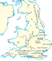
Ymele:Britain peoples circa 600.svg

Frumlicu ymele(SVG ymele, rihte 994 × 1,233 pixela, ymelan micelness: 1.88 MB)

Þeos ymele is fram Wikimedia Commons and man mot brucan hire on oðrum weorcum. Seo amearcung on hire tramete ymelan amearcunge þær is her geywed.

Towritenness
Deutsch: Landnahme der Angeln, Sachsen und Jüten auf den Britischen Inseln um das Jahr 600.
English: Peoples of Britain circa 600.
Español: Mapa da Bretanha ca. 600.
Français : La Grande-Bretagne vers 600.
Magyar: Brit népcsoportok 600 körül.
Polski: Ludy Brytanii ok. 600 r.
Português: Mapa da Bretanha ca. 600.
中文(中国大陆) 公元600年的不列颠。
Tælmearc
Fruma

Own work using:

  • File:Britain peoples circa 600.png by User:IMeowbot
  • Border data: CIA
  • People locations: The Historical Atlas by William R. Shepherd, 1926 edition, with clarifications supplied by en:User:Everyking per references used in en:Penda of Mercia.
  • Anglo-Saxon coastline: Hill, 'An Atlas of Anglo-Saxon England' (1981) (the grey areas marked 'sea, swamp or alluvium' show where little Anglo-Saxon settlement occurred, because (according to Hill) there was at different periods either large areas of mud, marshland or open sea).
Dædfruma User:Hel-hama
Leaf
(Eftnytt þisse ymelan)
GNU head Permission is granted to copy, distribute and/or modify this document under the terms of the GNU Free Documentation License, Version 1.2 or any later version published by the Free Software Foundation; with no Invariant Sections, no Front-Cover Texts, and no Back-Cover Texts. A copy of the license is included in the section entitled GNU Free Documentation License.
w:en:Creative Commons
hlígung Efenlice bryttiendlic
This file is licensed under the Creative Commons Attribution-Share Alike 3.0 Unported license.
Þu most:
  • bryttian – to copy, distribute and transmit the work
  • to remix – andwendan þæt weorc
Under the following conditions:
  • hlígung – You must give appropriate credit, provide a link to the license, and indicate if changes were made. You may do so in any reasonable manner, but not in any way that suggests the licensor endorses you or your use.
  • Efenlice bryttiendlic – Gif þu andwende þis weorc to ohte, þu scleat bryttian þæt andwendede weorc synderlice mid þære ilcan oþþe gelicre leafe swilcre þis brycþ.
This licensing tag was added to this file as part of the GFDL licensing update.
Other versions

[adiht]

Captions

Add a one-line explanation of what this file represents
Peoples of Britain circa 600.

Items portrayed in this file

depicts English

copyrighted English

inception English

17 Searmonað 2012

media type English

image/svg+xml

checksum English

645226d666cacd3f1de8ccd88cbad0b708aafc4f

determination method English: SHA-1 English

data size English

1,972,631 Bita

height English

1,233 pixel

width English

994 pixel

Ymelan stær

Swing dæg/tide mid mys to seonne þa ymelan swa heo wæs on þære tide geywed.

Dæg/TidMetungincelMicelnesse gemetuBrucendYmbspræc
nu16:03, 8 Mædmonað 2012Metungincel þære fadunge fram 16:03 on 8 Mædmonað 2012994 × 1,233 (1.88 MB)Hel-hamacoastline and text modified
10:42, 17 Sēremōnaþ 2012Metungincel þære fadunge fram 10:42 on 17 Sēremōnaþ 2012973 × 1,268 (4.16 MB)Hel-hamaRevised version of map using Shepherd's original version from http://www.lib.utexas.edu/maps/historical/history_shepherd_1923.html
20:58, 2 Haligmonað 2008Metungincel þære fadunge fram 20:58 on 2 Haligmonað 2008944 × 1,104 (362 KB)Wereon{{Information |Description= |Source= |Date= |Author= |Permission= |other_versions= }}
20:57, 2 Haligmonað 2008Metungincel þære fadunge fram 20:57 on 2 Haligmonað 2008944 × 1,104 (362 KB)Wereon. <!--{{ImageUpload|basic}}-->

Þā folgendan trametas bindaþ tō þissum biliðe:

Ymelan eormen nytt

Metagefræge