Ymele:Corse region relief location map.jpg

Micelness þisre forebysene: 304 be 600 dotta. Oðra metinga brædo: 121 be 240 dotta | 243 be 480 dotta | 824 be 1,625 dotta.
Frumlicu ymele (824 × 1,625 pixela, ymelan micelness: 324 KB, MIME cynn: image/jpeg)
Scortness
| Camera location | | View this and other nearby images on: OpenStreetMap |
|---|
| Towritenness |
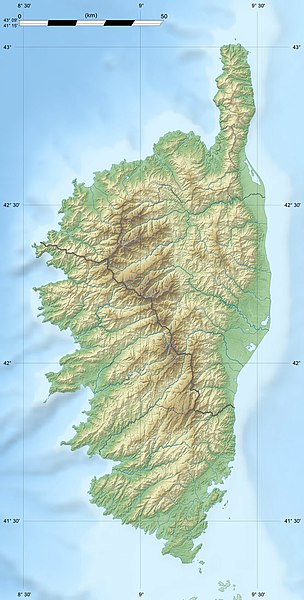
English: Blank physical map of the region of Corsica, France, for geo-location purpose, with distinct boundaries for departments and arrondissements as they are since January 2010.
The former version of the map shows the boundaries as they were until December 2009. Français : Carte physique vierge de la région Corse, France, destinée à la géolocalisation, avec limite distincte des départements et arrondissements tels que depuis janvier 2010. L'ancienne version de la carte montre le découpage administratif tel qu'il était jusqu'en décembre 2009. Scales: 1:520,000 (precision: 130 m) for the topography; 1:7,420,000 (precision: 1,855 m) for the bathymetry
Geographic limits of the map:
|
||
| Tælmearc | 2008-08, modified 02-2010 | ||
| Fruma |
Agen weorc
|
||
| Dædfruma | Eric Gaba (Sting - fr:Sting) | ||
| Leaf (Eftnytt þisse ymelan) |
|
||
| Other versions |
|

Leaf:
I, the copyright holder of this work, hereby publish it under the following licenses:
This file is licensed under the Creative Commons Attribution-Share Alike 3.0 Unported license.
- Þu most:
- bryttian – to copy, distribute and transmit the work
- to remix – andwendan þæt weorc
- Under the following conditions:
- hlígung – You must give appropriate credit, provide a link to the license, and indicate if changes were made. You may do so in any reasonable manner, but not in any way that suggests the licensor endorses you or your use.
- Efenlice bryttiendlic – Gif þu andwende þis weorc to ohte, þu scleat bryttian þæt andwendede weorc synderlice mid þære ilcan oþþe gelicre leafe swilcre þis brycþ.

|
Permission is granted to copy, distribute and/or modify this document under the terms of the GNU Free Documentation License, Version 1.2 or any later version published by the Free Software Foundation; with no Invariant Sections, no Front-Cover Texts, and no Back-Cover Texts. A copy of the license is included in the section entitled GNU Free Documentation License. |
Þu most ceosan leafe
Ymelan stær
Swing dæg/tide mid mys to seonne þa ymelan swa heo wæs on þære tide geywed.
| Dæg/Tid | Metungincel | Micelnesse gemetu | Brucend | Ymbspræc | |
|---|---|---|---|---|---|
| nu | 13:50, 18 Mædmonað 2010 | | 824 × 1,625 (324 KB) | Sting | Color profile |
| 18:33, 22 Solmonaþ 2010 |  | 824 × 1,625 (317 KB) | Sting | Updated arrondissments boundaries of Haute-Corse | |
| 19:50, 14 Weodmonað 2008 |  | 824 × 1,625 (315 KB) | Sting | == Summary == {{Location|42|12|00|N|09|03|00|E|scale:2000000}} <br/> {{Information |Description={{en|Blank physical map of the region of Corsica, France, for geo-location purpose, with distinct boundaries for departments and arrondissement |
Biliþbendas
Þā folgendan trametas bindaþ tō þissum biliðe:
Ymelan eormen nytt
Þas wiki brucaþ þissa ymelena:
- Nytt on als.wikipedia.org
- Nytt on ar.wikipedia.org
- Nytt on ast.wikipedia.org
- Nytt on bg.wikipedia.org
- Nytt on bn.wikipedia.org
- Nytt on bs.wikipedia.org
- Nytt on ca.wikipedia.org
- Nytt on ceb.wikipedia.org
- Nytt on cs.wikipedia.org
- Nytt on de.wikipedia.org
- Nytt on de.wikivoyage.org
- Nytt on dsb.wikipedia.org
- Nytt on el.wikipedia.org
- Nytt on en.wikipedia.org
View more global usage of this file.