Ymele:Detailed SVG map of the Anglophone world.svg

Size of this PNG preview of this SVG file: 800 be 411 dotta. Oðra metinga brædo: 320 be 164 dotta | 640 be 329 dotta | 1,024 be 526 dotta | 1,280 be 657 dotta | 2,560 be 1,314 dotta.
Frumlicu ymele (SVG ymele, rihte 2,560 × 1,314 pixela, ymelan micelness: 1.38 MB)
Scortness
| Towritenness |
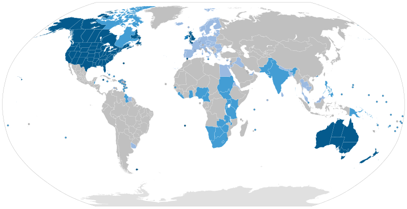
English: Majority native language
Co-official and majority native language
Official but minority native language
Secondary language: spoken as a second language by more than 20% of the population, de facto working language of government, language of instruction in education, etc. |
| Tælmearc | |
| Fruma | Speaker figures based on Ethnologue and other sources. Blank map: File:BlankMap-World6-Subdivisions.svg |
| Dædfruma | Jpthefish |
Leaf:
I, the copyright holder of this work, hereby publish it under the following license:
This file is licensed under the Creative Commons Attribution-Share Alike 4.0 International license.
- Þu most:
- bryttian – to copy, distribute and transmit the work
- to remix – andwendan þæt weorc
- Under the following conditions:
- hlígung – You must give appropriate credit, provide a link to the license, and indicate if changes were made. You may do so in any reasonable manner, but not in any way that suggests the licensor endorses you or your use.
- Efenlice bryttiendlic – Gif þu andwende þis weorc to ohte, þu scleat bryttian þæt andwendede weorc synderlice mid þære ilcan oþþe gelicre leafe swilcre þis brycþ.
Ymelan stær
Swing dæg/tide mid mys to seonne þa ymelan swa heo wæs on þære tide geywed.
| Dæg/Tid | Metungincel | Micelnesse gemetu | Brucend | Ymbspræc | |
|---|---|---|---|---|---|
| nu | 09:51, 26 Weodmonað 2023 | | 2,560 × 1,314 (1.38 MB) | Kwamikagami | rv: you just removed light blue, which we use on other maps |
| 01:35, 26 Weodmonað 2023 |  | 2,560 × 1,314 (1.36 MB) | Jpthefish | Reverted to version as of 01:23, 3 July 2020 (UTC) Forgive me if I am mistaken, but I have not seen sources to corroborate the light blue coloring of the EU, SE Asia, or other regions. The light blue color in my other maps was previously reserved for lanauges with cultural or secondary status - that is, a historically significant language and/or a language spoken by over 20% of the native population. I am open to changes though, as long as they are consistent across all SVG maps and reflect a... | |
| 05:42, 9 Weodmonað 2023 |  | 2,560 × 1,314 (1.38 MB) | Kwamikagami | some countries marked as majority English were majority creole | |
| 06:33, 15 Se Æfterra Gēola 2023 |  | 2,560 × 1,314 (1.38 MB) | Kwamikagami | clean up Quebec; Faroes assumed | |
| 05:50, 15 Se Æfterra Gēola 2023 |  | 2,560 × 1,314 (1.38 MB) | Kwamikagami | 2nd language >20%, & de facto govt working language, per Ethnologue. | |
| 01:23, 3 Mædmonað 2020 |  | 2,560 × 1,314 (1.36 MB) | Jpthefish | New section | |
| 22:47, 8 Sēremōnaþ 2020 |  | 2,560 × 1,314 (1.36 MB) | Jpthefish | Lighter secondary colors | |
| 17:17, 25 Þrimilcemonað 2020 |  | 2,560 × 1,314 (1.36 MB) | Jpthefish | edit Channel Islands | |
| 18:19, 8 Þrimilcemonað 2020 |  | 2,560 × 1,314 (1.36 MB) | Jpthefish | Add Cameroon | |
| 02:15, 8 Þrimilcemonað 2020 |  | 2,560 × 1,314 (1.36 MB) | Jpthefish | Uploaded own work with UploadWizard |
Biliþbendas
Þā folgendan trametas bindaþ tō þissum biliðe:
Ymelan eormen nytt
Þas wiki brucaþ þissa ymelena:
- Nytt on af.wikipedia.org
- Nytt on ar.wikipedia.org
- Nytt on ast.wikipedia.org
- Nytt on av.wikipedia.org
- Nytt on az.wikipedia.org
- Nytt on ba.wikipedia.org
- Nytt on be.wikipedia.org
- Nytt on bg.wikipedia.org
- Nytt on bn.wikipedia.org
- Nytt on br.wikipedia.org
- Nytt on cv.wikipedia.org
- Nytt on en.wikipedia.org
- Nytt on en.wikibooks.org
- Nytt on es.wikipedia.org
- Nytt on fa.wikipedia.org
- Nytt on fr.wikipedia.org
- Nytt on ga.wikipedia.org
- Nytt on guc.wikipedia.org
- Nytt on he.wikipedia.org
- Nytt on hr.wikipedia.org
- Nytt on hy.wikipedia.org
- Nytt on id.wikipedia.org
- Nytt on incubator.wikimedia.org
- Nytt on it.wikipedia.org
- Nytt on ka.wikipedia.org
View more global usage of this file.