Ymele:Douglas County Kansas Incorporated and Unincorporated areas Lawrence Highlighted.svg

Size of this PNG preview of this SVG file: 799 be 329 dotta. Oðra metinga brædo: 320 be 132 dotta | 640 be 264 dotta | 1,024 be 422 dotta | 1,280 be 527 dotta | 2,560 be 1,054 dotta | 850 be 350 dotta.
Frumlicu ymele (SVG ymele, rihte 850 × 350 pixela, ymelan micelness: 2.04 MB)
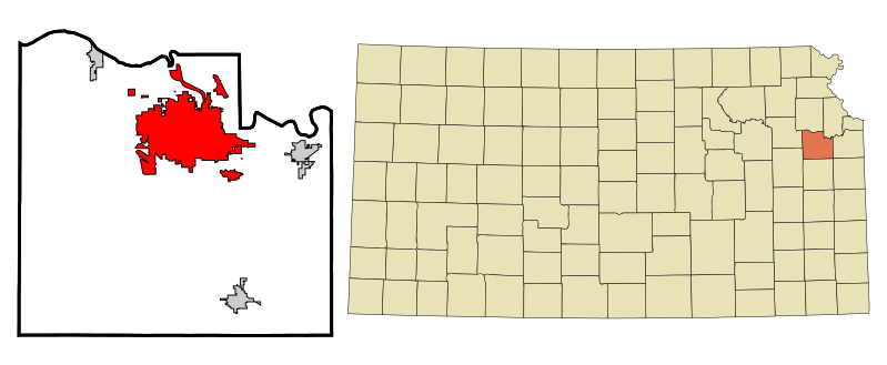
| Towritenness | This map shows the incorporated and unincorporated areas in Douglas County, Kansas, highlighting Lawrence in red. It was created with a custom script with US Census Bureau data and modified with Inkscape. |
| Tælmearc | |
| Fruma | My own work, based on public domain information. Based on similar map concepts by Ixnayonthetimmay |
| Dædfruma | Arkyan |
I, the copyright holder of this work, hereby publish it under the following licenses:

|
Permission is granted to copy, distribute and/or modify this document under the terms of the GNU Free Documentation License, Version 1.2 or any later version published by the Free Software Foundation; with no Invariant Sections, no Front-Cover Texts, and no Back-Cover Texts. A copy of the license is included in the section entitled GNU Free Documentation License. |
| This file is licensed under the Creative Commons Attribution-Share Alike 3.0 Unported license. | ||
| ||
| This licensing tag was added to this file as part of the GFDL licensing update. |
This file is licensed under the Creative Commons Attribution-Share Alike 2.5 Generic, 2.0 Generic and 1.0 Generic license.
- Þu most:
- bryttian – to copy, distribute and transmit the work
- to remix – andwendan þæt weorc
- Under the following conditions:
- hlígung – You must give appropriate credit, provide a link to the license, and indicate if changes were made. You may do so in any reasonable manner, but not in any way that suggests the licensor endorses you or your use.
- Efenlice bryttiendlic – Gif þu andwende þis weorc to ohte, þu scleat bryttian þæt andwendede weorc synderlice mid þære ilcan oþþe gelicre leafe swilcre þis brycþ.
Þu most ceosan leafe
Ymelan stær
Swing dæg/tide mid mys to seonne þa ymelan swa heo wæs on þære tide geywed.
| Dæg/Tid | Metungincel | Micelnesse gemetu | Brucend | Ymbspræc | |
|---|---|---|---|---|---|
| nu | 23:32, 31 Weodmonað 2011 | 850 × 350 (2.04 MB) | Afarina~commonswiki | Updated municipal boundaries as of July 2011, using official maps from Douglas County and City of Lawrence websites | |
| 18:30, 15 Winterfylleð 2007 | 850 × 350 (112 KB) | ArkyBot~commonswiki | {{Information |Description=This map shows the incorporated and unincorporated areas in Douglas County, Kansas, highlighting Lawrence in red. It was created wit |
Biliþbendas
Þā folgendan trametas bindaþ tō þissum biliðe:
Ymelan eormen nytt
Þas wiki brucaþ þissa ymelena:
- Nytt on ar.wikipedia.org
- Nytt on arz.wikipedia.org
- Nytt on azb.wikipedia.org
- Nytt on bn.wikipedia.org
- Nytt on ca.wikipedia.org
- Nytt on ceb.wikipedia.org
- Nytt on de.wikipedia.org
- Nytt on en.wikipedia.org
- Nytt on eo.wikipedia.org
- Nytt on et.wikipedia.org
- Nytt on eu.wikipedia.org
- Nytt on fa.wikipedia.org
- Nytt on fi.wikipedia.org
- Nytt on fr.wikipedia.org
- Nytt on ht.wikipedia.org
- Nytt on hu.wikipedia.org
- Nytt on ia.wikipedia.org
- Nytt on it.wikipedia.org
- Nytt on ja.wikipedia.org
- Nytt on ko.wikipedia.org
- Nytt on mr.wikipedia.org
- Nytt on nl.wikipedia.org
- Nytt on pt.wikipedia.org
- Nytt on sh.wikipedia.org
- Nytt on simple.wikipedia.org
- Nytt on sr.wikipedia.org
- Nytt on tr.wikipedia.org
- Nytt on tt.wikipedia.org
- Nytt on ur.wikipedia.org
- Nytt on vi.wikipedia.org
- Nytt on vo.wikipedia.org
- Nytt on www.wikidata.org
- Nytt on zh-min-nan.wikipedia.org
- Nytt on zh.wikipedia.org