Ymele:KgrWuerttemberg.png

Micelness þisre forebysene: 464 be 599 dotta. Oðra metinga brædo: 186 be 240 dotta | 372 be 480 dotta | 595 be 768 dotta | 793 be 1,024 dotta | 1,524 be 1,968 dotta.
Frumlicu ymele (1,524 × 1,968 pixela, ymelan micelness: 120 KB, MIME cynn: image/png)
| Towritenness |
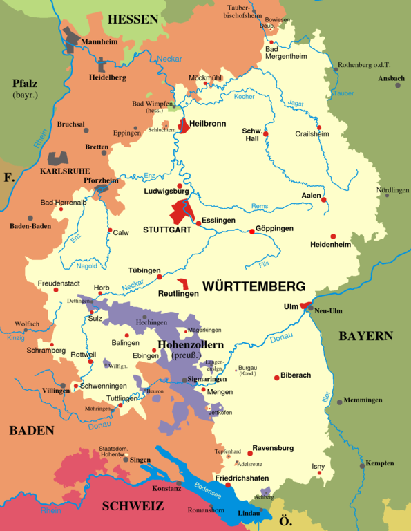
Deutsch: Karte von Württemberg, Zustand von 1810-1945. Weitere Details zum Territorium siehe unter territoriale Besonderheiten.
English: Map of Württemberg from 1810-1945. |
||||||||
| Tælmearc | |||||||||
| Fruma | Agen weorc | ||||||||
| Dædfruma | Ssch | ||||||||
| Leaf (Eftnytt þisse ymelan) |
|
||||||||
| Other versions |
Derivative works of this file: Swabia-map.PNG none |

Ymelan stær
Swing dæg/tide mid mys to seonne þa ymelan swa heo wæs on þære tide geywed.
| Dæg/Tid | Metungincel | Micelnesse gemetu | Brucend | Ymbspræc | |
|---|---|---|---|---|---|
| nu | 09:53, 2 Gēolmōnaþ 2006 | | 1,524 × 1,968 (120 KB) | Ssch~commonswiki | Corrected the border at Ruchsen (near Möckmühl) |
| 18:27, 12 Winterfylleð 2005 |  | 1,524 × 1,968 (120 KB) | Ssch~commonswiki | Corrected the border with Hohenzollern - Jettkofen was not an exclave, but connected to Württemberg by a thin strip of land. | |
| 10:10, 2 Winterfylleð 2005 |  | 1,524 × 1,968 (119 KB) | Ssch~commonswiki | Map of the Kingdom of Württemberg from 1810-1945. Drawn by myself. |
Biliþbendas
Þǣr sind nāne trametas þe bindaþ tō þissum biliðe.
Ymelan eormen nytt
Þas wiki brucaþ þissa ymelena:
- Nytt on als.wikipedia.org
- Nytt on ar.wikipedia.org
- Nytt on ast.wikipedia.org
- Nytt on azb.wikipedia.org
- Nytt on bg.wikipedia.org
- Nytt on br.wikipedia.org
- Nytt on ca.wikipedia.org
- Nytt on cs.wikipedia.org
- Nytt on da.wikipedia.org
- Nytt on de.wikipedia.org
- Württemberg
- Königreich Württemberg
- Schlacht bei Nördlingen
- Diskussion:Dreiländereck
- Benutzer:Ssch
- Volksstaat Württemberg
- Grenzvertrag zwischen Württemberg und Baden
- Württemberg zur Zeit des Nationalsozialismus
- Benutzer Diskussion:Ssch/Archiv 2014
- Wikipedia:Kartenwerkstatt/Archiv/2014-06
- Wikipedia Diskussion:Hauptseite/Artikel des Tages/2025
- Benutzer:Wurgl/Fehler PD
- Nytt on de.wiktionary.org
- Nytt on en.wikipedia.org
- Nytt on eo.wikipedia.org
- Nytt on es.wikipedia.org
- Nytt on et.wikipedia.org
- Nytt on fa.wikipedia.org
- Nytt on fi.wikipedia.org
- Nytt on fr.wikipedia.org
- Nytt on he.wikipedia.org
- Nytt on hr.wikipedia.org
- Nytt on hu.wikipedia.org
- Nytt on id.wikipedia.org
- Nytt on it.wikipedia.org
View more global usage of this file.