Ymele:Map of Poland (1945).png
Nænig mare micelness nis brucendlicu.
Map_of_Poland_(1945).png (594 × 513 pixela, ymelan micelness: 13 KB, MIME cynn: image/png)
.png)

|
This historical map image could be re-created using vector graphics as an SVG file. This has several advantages; see Commons:Media for cleanup for more information. If an SVG form of this image is available, please upload it and afterwards replace this template with
{{vector version available|new image name}}.
It is recommended to name the SVG file “Map of Poland (1945).svg”—then the template Vector version available (or Vva) does not need the new image name parameter. |
Scortness
| Towritenness |
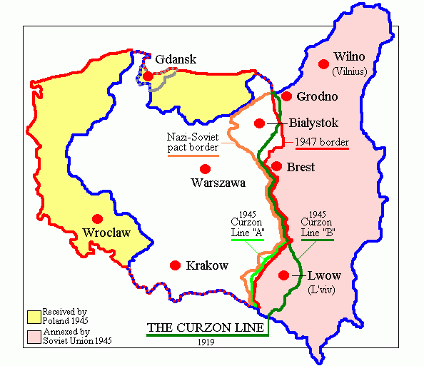
English: Map of Poland in 1945.
Deutsch: Karte Polens (1945). |
| Tælmearc | |
| Fruma | Agen weorc (originally at en.wikipedia) |
| Dædfruma | Adam Carr |
| Other versions | Derivative works of this file: Polszczyzna kresowa.png |
Leaf:
| |
This work has been released into the public domain by its author, Adam Carr, at the English Ƿikipǣdia project. This applies worldwide. In case this is not legally possible: |
Ymelan stær
Swing dæg/tide mid mys to seonne þa ymelan swa heo wæs on þære tide geywed.
| Dæg/Tid | Metungincel | Micelnesse gemetu | Brucend | Ymbspræc | |
|---|---|---|---|---|---|
| nu | 18:29, 18 Sēremōnaþ 2018 | | 594 × 513 (13 KB) | Julieta39 | According with 1919 maps |
| 03:57, 30 Sēremōnaþ 2016 |  | 594 × 513 (15 KB) | Poeticbent | r/m dead space, spelling | |
| 07:58, 12 Solmonaþ 2007 |  | 617 × 513 (9 KB) | Unomano | Map of Poland in 1945, drawn by en:User: Adam Carr. From en:Image:Map of Poland (1945).png {{PD-user-w|en|English Wikipedia|Adam Carr}} Category:Maps of the history of Poland | |
| 14:43, 2 Gēolmōnaþ 2005 |  | 617 × 513 (9 KB) | Thuresson | Map of Poland in 1945, drawn by User: Adam Carr. From en:Image:Map of Poland (1945).png {{PD-user-w|en|English Wikipedia|Adam Carr}} Category:Historical maps of Poland |
.png)
Biliþbendas
Þā folgendan trametas bindaþ tō þissum biliðe:
Ymelan eormen nytt
Þas wiki brucaþ þissa ymelena:
- Nytt on ar.wikipedia.org
- Nytt on be-tarask.wikipedia.org
- Nytt on be.wikipedia.org
- Nytt on bg.wikipedia.org
- Nytt on ca.wikipedia.org
- Nytt on cs.wikipedia.org
- Nytt on de.wikibooks.org
- Nytt on el.wikipedia.org
- Nytt on en.wikipedia.org
- Polish People's Republic
- User:Adam Carr/My archive of original cartographic contributions
- History of German settlement in Central and Eastern Europe
- User:Landau7
- Talk:Flight and expulsion of Germans (1944–1950)/Archive 10
- Polish population transfers (1944–1946)
- User:TheNoiseBringer
- User:Halibutt/expulsion
- User:Falcaorib
- Nytt on es.wikipedia.org
- Nytt on fa.wikipedia.org
- Nytt on fr.wikipedia.org
- Nytt on id.wikipedia.org
- Nytt on it.wikipedia.org
- Nytt on kk.wikipedia.org
- Nytt on lv.wikipedia.org
- Nytt on nl.wikipedia.org
- Nytt on pt.wikipedia.org
- Nytt on ro.wikipedia.org
View more global usage of this file.
.png)
.png)