Ymele:Maricopa County Incorporated and Planning areas Glendale highlighted.svg

Size of this PNG preview of this SVG file: 694 be 599 dotta. Oðra metinga brædo: 278 be 240 dotta | 556 be 480 dotta | 889 be 768 dotta | 1,185 be 1,024 dotta | 2,371 be 2,048 dotta | 940 be 812 dotta.
Frumlicu ymele (SVG ymele, rihte 940 × 812 pixela, ymelan micelness: 1.05 MB)
Scortness
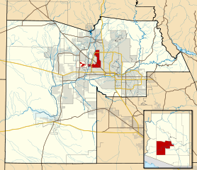
| Towritenness | This map shows the incorporated areas and Indian reservation boundaries in Maricopa County, Arizona, along with water bodies and major highways and roads. Glendale is highlighted in red. Other incorporated cities are shown in gray, planning area borders for these cities and Indian reservation borders are shown as solid black lines. Changes from Previous Version: Updated the maps to include water bodies and to make "less boring" than the plain black/white/gray maps. Format was updated to match standards laid out by WikiProject Maps/Conventions. Map data is based on data from the following Webpage: Maricopa County Interactive GIS Map. I created this map in Inkscape. |
| Tælmearc | |
| Fruma | My own work, based on government information |
| Dædfruma | Ixnayonthetimmay |
| Leaf (Eftnytt þisse ymelan) |
Public Domain |
| Other versions | See Category:Maps of Maricopa County for other versions of this image. |
Leaf:
| I, the copyright holder of this work, release this work into the public domain. This applies worldwide. In some countries this may not be legally possible; if so: I grant anyone the right to use this work for any purpose, without any conditions, unless such conditions are required by law. |
Ymelan stær
Swing dæg/tide mid mys to seonne þa ymelan swa heo wæs on þære tide geywed.
| Dæg/Tid | Metungincel | Micelnesse gemetu | Brucend | Ymbspræc | |
|---|---|---|---|---|---|
| nu | 06:32, 20 Þrimilcemonað 2011 | | 940 × 812 (1.05 MB) | Ixnayonthetimmay | Uploading new version |
| 04:10, 30 Weodmonað 2008 |  | 900 × 800 (423 KB) | Ixnayonthetimmay | == Summary == {{Information |Description=This map shows the incorporated areas and unincorporated areas in Maricopa County, Arizona. [[:en:Glendale, Arizona| | |
| 00:16, 16 Haligmonað 2007 |  | 900 × 800 (384 KB) | Ixnayonthetimmay | {{Information |Description= |Source= |Date= |Author= |Permission= |other_versions= }} | |
| 10:00, 28 Þrimilcemonað 2007 |  | 900 × 780 (329 KB) | Ixnayonthetimmay | ||
| 00:07, 22 Þrimilcemonað 2007 |  | 900 × 780 (318 KB) | Ixnayonthetimmay | ||
| 05:05, 30 Se Æfterra Gēola 2007 |  | 904 × 758 (189 KB) | Ixnayonthetimmay | {{Information |Description=This map shows the incorporated areas in Maricopa County, Arizona, highlighting Glendale in red. It also shows the boundaries for the |
Biliþbendas
Þā folgendan trametas bindaþ tō þissum biliðe:
Ymelan eormen nytt
Þas wiki brucaþ þissa ymelena:
- Nytt on ar.wikipedia.org
- Nytt on arz.wikipedia.org
- Nytt on br.wikipedia.org
- Nytt on ca.wikipedia.org
- Nytt on ceb.wikipedia.org
- Nytt on de.wikipedia.org
- Nytt on el.wikipedia.org
- Nytt on eo.wikipedia.org
- Nytt on es.wikipedia.org
- Nytt on eu.wikipedia.org
- Nytt on fa.wikipedia.org
- Nytt on fi.wikipedia.org
- Nytt on fr.wikipedia.org
- Nytt on ga.wikipedia.org
- Nytt on glk.wikipedia.org
- Nytt on gl.wikipedia.org
- Nytt on hr.wikipedia.org
- Nytt on ht.wikipedia.org
- Nytt on hu.wikipedia.org
- Nytt on id.wikipedia.org
- Nytt on ja.wikipedia.org
- Nytt on kw.wikipedia.org
- Nytt on mrj.wikipedia.org
- Nytt on ms.wikipedia.org
- Nytt on mzn.wikipedia.org
- Nytt on pt.wikipedia.org
- Nytt on ro.wikipedia.org
- Nytt on sco.wikipedia.org
- Nytt on sr.wikipedia.org
- Nytt on sw.wikipedia.org
- Nytt on ta.wikipedia.org
- Nytt on tr.wikipedia.org
- Nytt on tt.wikipedia.org
- Nytt on ur.wikipedia.org
- Nytt on vi.wikipedia.org
- Nytt on vo.wikipedia.org
- Nytt on www.wikidata.org