Ymele:South Island.jpg

Frumlicu ymele (2,618 × 2,926 pixela, ymelan micelness: 1.26 MB, MIME cynn: image/jpeg)
Scortness
| Towritenness |
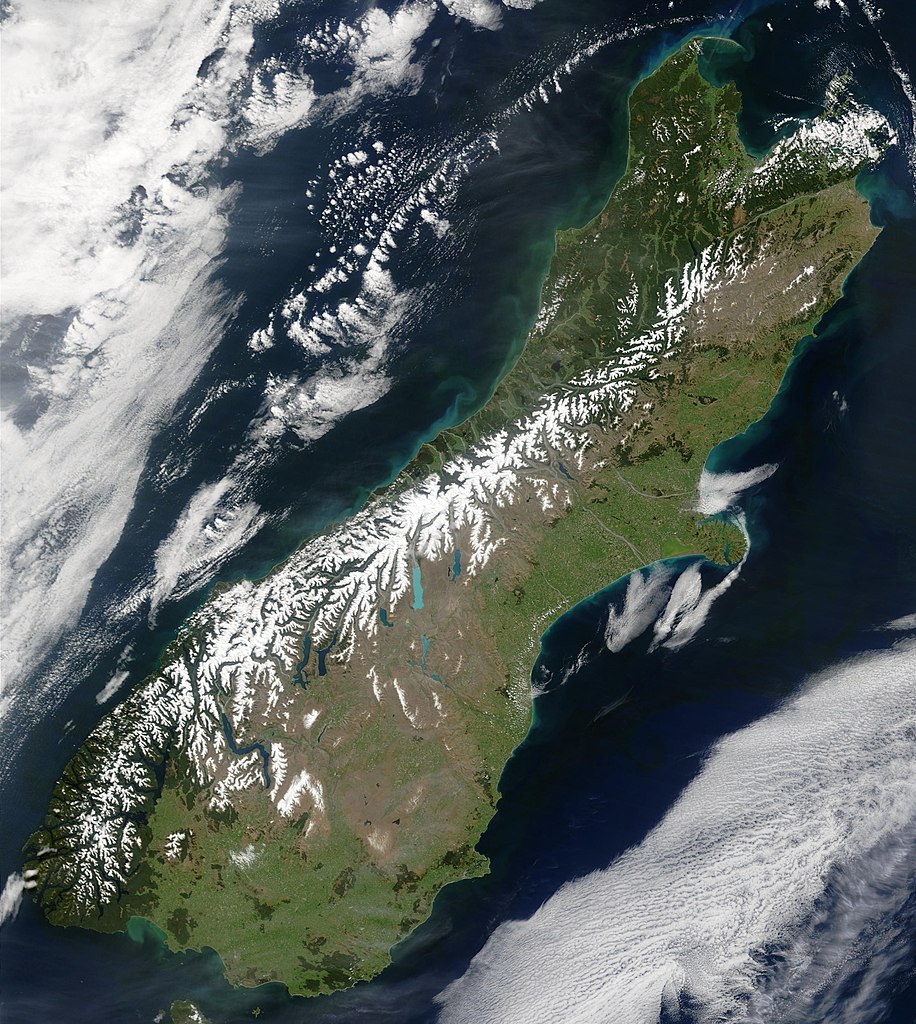
English: This true-color image provides a nearly cloud-free look at the South Island of New Zealand, from NASA’s Terra satellite.
Українська: Сніг виділяє гірські хребти Південних Альп (супутниковий знімок НАСА), Нова Зеландія. |
| Tælmearc | |
| Fruma | NASA's Earth Observatory |
| Dædfruma | Jacques Descloitres, MODIS Land Rapid Response Team at NASA GSFC |
| Leaf (Eftnytt þisse ymelan) |
Public domain - original work of NASA |
| Other versions | Image:South.island.arp.750pix.jpg is lower resolution, more tightly cropped |
This true-color image provides a nearly cloud-free look at the South Island of New Zealand. The scene was acquired by NASA’s Terra satellite, on October 23, 2002.
Forested areas are clearly indicated by the very dark green, particularly in the northwest and southwest. The braided Waimakariri and Rakaia rivers can also clearly be seen as they make their way to the east coast on either side of Banks Peninsula.
Image courtesy Jacques Descloitres, MODIS Land Rapid Response Team at NASA GSFC.
SOURCE: http://earthobservatory.nasa.gov/Newsroom/NewImages/images.php3?img_id=10881
”The purpose of NASA's Earth Observatory is to provide a freely-accessible publication on the Internet where the public can obtain new satellite imagery and scientific information about our home planet. The focus is on Earth's climate and environmental change. In particular, we hope our site is useful to public media and educators. Any and all materials published on the Earth Observatory are freely available for re-publication or re-use, except where copyright is indicated. We ask that NASA's Earth Observatory be given credit for its original materials.”
Leaf:
| This file is in the public domain in the United States because it was solely created by NASA. NASA copyright policy states that "NASA material is not protected by copyright unless noted". (See Template:PD-USGov, NASA copyright policy page or JPL Image Use Policy.) | ||
 |
Warnings:
|
Ymelan stær
Swing dæg/tide mid mys to seonne þa ymelan swa heo wæs on þære tide geywed.
| Dæg/Tid | Metungincel | Micelnesse gemetu | Brucend | Ymbspræc | |
|---|---|---|---|---|---|
| nu | 00:48, 18 Þrimilcemonað 2006 | | 2,618 × 2,926 (1.26 MB) | Avenue | {{Information| |Description=This true-color image provides a nearly cloud-free look at the South Island of New Zealand, from NASA’s Terra satellite. |Source=[http://earthobservatory.nasa.gov/Newsroom/NewImages/images.php3?img_id=10881 NASA's Earth Obser |
Biliþbendas
Þā folgendan trametas bindaþ tō þissum biliðe:
Ymelan eormen nytt
Þas wiki brucaþ þissa ymelena:
- Nytt on af.wikipedia.org
- Nytt on an.wikipedia.org
- Nytt on ar.wikipedia.org
- Nytt on bh.wikipedia.org
- Nytt on ceb.wikipedia.org
- Nytt on cs.wikipedia.org
- Nytt on da.wikipedia.org
- Nytt on de.wikipedia.org
- Nytt on de.wikivoyage.org
- Nytt on el.wikipedia.org
- Nytt on en.wikipedia.org
- Nytt on en.wikiversity.org
- Nytt on eo.wikipedia.org
- Nytt on et.wikipedia.org
- Nytt on fa.wikipedia.org
- Nytt on fi.wikipedia.org
- Nytt on fr.wikipedia.org
- Nytt on gl.wikipedia.org
- Nytt on he.wikipedia.org
- Nytt on hi.wikipedia.org
- Nytt on hr.wikipedia.org
- Nytt on hu.wikipedia.org
- Nytt on is.wikipedia.org
- Nytt on it.wikipedia.org
- Nytt on ja.wikipedia.org
- Nytt on mi.wikipedia.org
- Nytt on mk.wikipedia.org
- Nytt on ml.wikipedia.org
- Nytt on mn.wikipedia.org
- Nytt on nl.wikipedia.org
- Nytt on nn.wikipedia.org
- Nytt on no.wikipedia.org
- Nytt on oc.wikipedia.org
- Nytt on pnb.wikipedia.org
- Nytt on pt.wikipedia.org
- Nytt on sh.wikipedia.org
- Nytt on sk.wikipedia.org
- Nytt on sl.wikipedia.org
- Nytt on sr.wikipedia.org
- Nytt on sv.wikipedia.org
- Nytt on tpi.wikipedia.org
- Nytt on tr.wikipedia.org
- Nytt on zh-min-nan.wikipedia.org
View more global usage of this file.