Ymele:USA Territorial Growth 1820 alt.jpg

Micelness þisre forebysene: 800 be 369 dotta. Oðra metinga brædo: 320 be 148 dotta | 640 be 295 dotta | 1,192 be 550 dotta.
Frumlicu ymele (1,192 × 550 pixela, ymelan micelness: 131 KB, MIME cynn: image/jpeg)
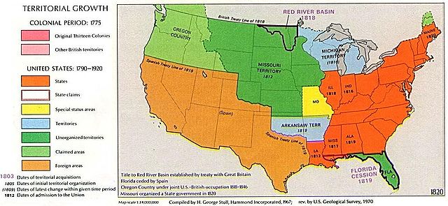
1970 USGS map
This image is in the public domain in the United States because it only contains materials that originally came from the United States Geological Survey, an agency of the United States Department of the Interior. For more information, see the official USGS copyright policy.
|
Other versions: 
Visually reorganized by Beyond My Ken (talk) 22:01, 18 April 2010 (UTC)
| US growth maps |
| Animated: large · small |
| Years |
| 1775 · 1790 · 1800 · 1810 · 1820 · 1830 · 1840 · 1850 · 1860 · 1870 · 1880 · 1900 · 1920 |

|
This historical map image could be re-created using vector graphics as an SVG file. This has several advantages; see Commons:Media for cleanup for more information. If an SVG form of this image is available, please upload it and afterwards replace this template with
{{vector version available|new image name}}.
It is recommended to name the SVG file “USA Territorial Growth 1820 alt.svg”—then the template Vector version available (or Vva) does not need the new image name parameter. |


Ymelan stær
Swing dæg/tide mid mys to seonne þa ymelan swa heo wæs on þære tide geywed.
| Dæg/Tid | Metungincel | Micelnesse gemetu | Brucend | Ymbspræc | |
|---|---|---|---|---|---|
| nu | 22:02, 18 Eastermonað 2010 | | 1,192 × 550 (131 KB) | Beyond My Ken | First upload failed |
| 22:01, 18 Eastermonað 2010 |  | 1,192 × 550 (131 KB) | Beyond My Ken | 1970 USGS map {{PD-USGov-USGS}} Other versions: 150px Visually reorganized by ~~~~ {{US growth maps}} {{svg|map}} Category:Territorial Growth Maps of the United States |
Biliþbendas
Þā folgendan trametas bindaþ tō þissum biliðe:
Ymelan eormen nytt
Þas wiki brucaþ þissa ymelena:
- Nytt on ar.wikipedia.org
- Nytt on da.wikipedia.org
- Nytt on en.wikipedia.org
- Nytt on es.wikipedia.org
- Nytt on eu.wikipedia.org
- Nytt on fr.wikipedia.org
- Nytt on he.wikipedia.org
- Nytt on id.wikipedia.org
- Nytt on it.wikipedia.org
- Nytt on ko.wikipedia.org
- Nytt on ms.wikipedia.org
- Nytt on no.wikipedia.org
- Nytt on sv.wikipedia.org
- Nytt on zh.wikipedia.org